A large detailed map of Manitoba
This is a large, detailed map of Manitoba. There are links to many Manitoba localities below. Our website format reduces the display size for uniformity. Here is a link to the full-size image that is more easily readable.
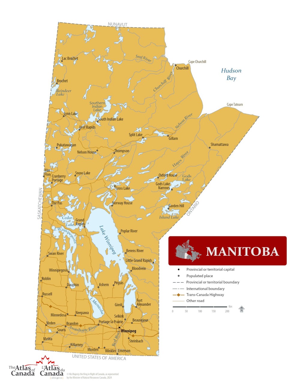
Map © Natural Resources Canada / Government of Canada
Manitoba — Interactive Map
Explore Manitoba with an interactive map featuring Street View, satellite and terrain views. Live weather, local news and location details for Manitoba — built for travel planning and emergencies.
Map search is available for a limited number of queries per session to manage costs. Be specific — search precisely for best results.
| Province / Territory | Manitoba (MB) |
| Capital | Winnipeg |
| Largest City | Winnipeg |
| Country | Canada |
| Nickname | Keystone Province |
| Latitude | 56.415 |
| Longitude | -98.739 |
| Population | 1,342,153 |
| Cities & Towns | 1,426 |
| Area | 647,797 km² |
About Manitoba
Manitoba holds a vast and singular terrain that stretches from the frozen lip of Hudson Bay to the sun-bleached grasslands of the south. Great rivers like the Nelson and the Churchill carve deep, winding paths through the boreal shield, carrying the weight of ancient ice-melt toward the salt waters of the north. In the central reaches of the land, the earth flattens into the remnants of a prehistoric sea, creating a horizon that seems to pull the sky down until it brushes against the wheat. Vast networks of lakes, including the sprawling expanse of Lake Winnipeg, act as inland seas that temper the fierce, continental extremes of the climate. Manitoba possesses a rugged, unforgiving beauty where the light shifts sharply between the biting clarity of winter and the long, golden afternoons of summer. Forests of spruce and tamarack stand as silent observers across the rugged midsection, marking a transition between the rocky Canadian Shield and the fertile plains.
Indigenous peoples have served as the original stewards of this expansive territory for millennia, maintaining a profound connection to the waterways and the seasonal migration of the land’s creatures. Following the arrival of European fur traders, Manitoba became a focal point for commerce and colonial expansion, eventually emerging as a distinct entity within the young nation. The Red River colony grew into a hub of social and political change, where settlers and the Métis people navigated the complexities of a shifting frontier. Through periods of intense growth and difficult struggle, the borders of Manitoba solidified into the shape recognized today. History here is found in the weathered stone of old trading posts and the persistent memory of the trails that once linked the northern woods to the southern prairie. The evolution of the region reflects a persistent drive to build a life in a land that demands both resilience and ingenuity from its inhabitants.
Agriculture remains a fundamental pillar of the economy in Manitoba, with the southern plains providing some of the most productive soil for cereal crops and livestock on the continent. Beyond the fields, the province draws significant wealth from the extraction of minerals and the generation of hydroelectric power, which lights the homes of millions through the harnessed force of northern rivers. Manufacturing and aerospace industries thrive in the urban centres, contributing to a diverse marketplace that balances natural resource reliance with modern technological output. The city of Winnipeg serves as a vital logistics hub, connecting the east and west through rail lines and international shipping corridors. Tourism also plays a growing role, inviting visitors to witness the polar bears of the north or the quiet solitude of provincial parks. Manitoba continues to refine its economic character by leaning into its geographic advantages and the industrious spirit of its people.
Sporting life in Manitoba pulses with a particular intensity, especially when the winter chill sets in and the arenas fill with the roar of hockey fans cheering for the Jets. The passion for the game extends to the gridiron, where the Blue Bombers command a dedicated following during the crisp autumn months of the football season. Festivals celebrate the diverse heritage of the region, from the vibrant gatherings in the French Quarter to the winter celebrations that honour the persistence of life in the cold. Culinary traditions draw from a mix of wild-harvested foods and the bounty of local farms, offering flavours that are as grounded as the earth itself. Daily life moves with a steady, deliberate pace, where neighbours share stories over coffee and the vastness of the sky provides a constant backdrop to human activity. Manitoba fosters a culture that values community and hard work, ensuring that every season is met with a sense of purpose and local pride.
Manitoba Cities, Towns and Communities
A
B
C
D
E
F
G
H
I
J
K
L
M
N
O
P
Q
R
S
T
U
V
W
Manitoba Maps — Interactive Map, Street View, Weather & News
This page provides an interactive Google map of Manitoba (MB) with Street View, satellite and terrain views, alongside links to detailed street maps for 1,426 cities, towns and communities across the province. The provincial capital is Winnipeg.
Every location page includes live weather through Open-Meteo — with current conditions, hourly outlooks and 7-day forecasts — alongside real-time local and world news feeds. Editorial summaries and location descriptions are included where available, and visitors can search Google directly from each page for additional context.
The Search Maps button below the map opens the Canada Base Map with Toporama contours and shaded relief as base layers, with a labelled UTM grid overlay, a distance and bearing tool, and a single-fix GPS readout giving your UTM/MGRS grid reference and latitude and longitude.
Location data is sourced from the Canadian Geographical Names Database (CGN), Natural Resources Canada, and verified by coordinates rather than name matching alone.