Map Canada
Explore Canada with this interactive map featuring Street View, satellite and terrain views. Our 25,108+ location pages are real-time information hubs — built for travel planning, research and emergencies, including storms, flooding and severe weather events.
Interactive Map of Canada
Map search is available for a limited number of queries per session to manage costs. Be specific — search precisely for best results.
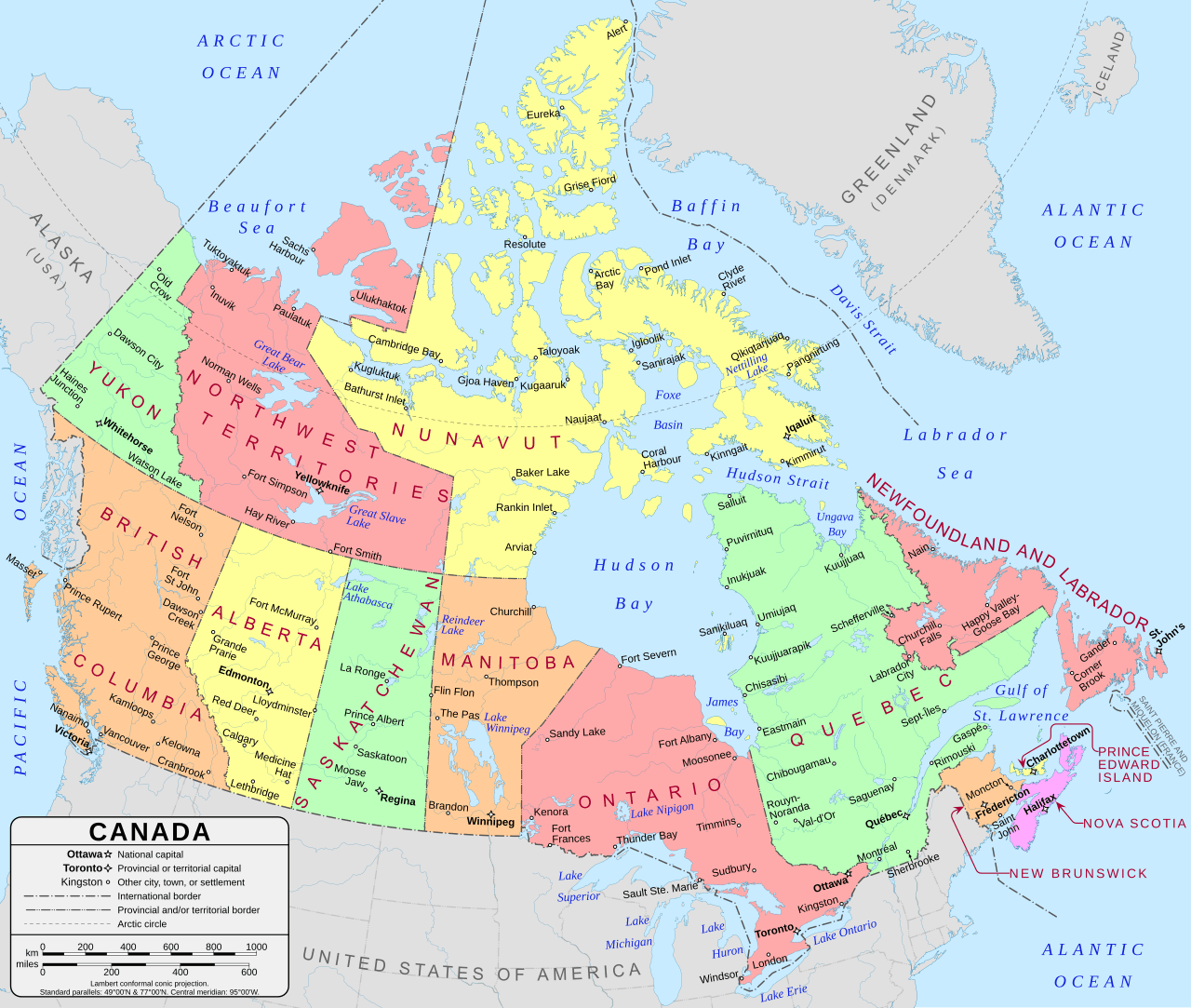
A map of Canadian Provinces & Territories
This is a large, detailed map of Canada showing all provinces and territories. There are links to province and territory map pages below. Our website format reduces the display size for uniformity. Here is a link to the full-size image that is more easily readable.
This file is licensed under the Creative Commons Attribution-Share Alike 4.0 International license.
Canadian Province & Territory Maps
Provinces
Territories
Largest Canadian Cities
| Country | Canada |
| Capital | Ottawa, ON |
| Largest City | Toronto |
| Official Languages | English & French |
| Provinces & Territories | 10 provinces, 3 territories |
| Currency | Canadian Dollar (CAD) |
| Latitude | 56.1304°N |
| Longitude | 106.3468°W |
| Population | ~40,500,000 |
| Area | 9,984,670 km² |
| Timezone | Multiple (UTC−8 to UTC−3:30) |
| Driving Side | Right |
About Canada
Canada stretches across a staggering breadth of northern terrain, defined by the ancient, weathered granite of the Canadian Shield that anchors its midsection. From the jagged, snow-dusted peaks of the Rocky Mountains in the west to the rolling, fertile lowlands of the east, the land offers a stark contrast in geological temperaments. Endless boreal forests sweep across the interior, giving way to the vast, flat expanse of the prairies and the desolate, wind-scoured reaches of the Arctic tundra. The Great Lakes act as massive, freshwater reservoirs that temper the climate, while three distinct oceans beat against the rocky Atlantic, Pacific, and Arctic coastlines. Winter claims the northern reaches with a relentless, frigid grip, while the maritime regions experience the damp, grey softness of a coastal thaw.
First Nations, Inuit, and Métis peoples have acted as the enduring stewards of this vast territory for millennia, maintaining deep connections to the land long before the arrival of European explorers. The subsequent influence of French and British colonial powers left a permanent mark on the administrative and social structures of Canada, leading to the formal confederation that unified disparate colonies in 1867. Modern Canada functions as a bilingual and deeply multicultural society, concentrating much of its population in southern corridors while maintaining a profound respect for the sparsely populated northern hinterlands. Cities like Toronto and Vancouver thrive as dense, energetic hubs of human activity, yet they remain shadowed by the immense wilderness that dictates the broader character of the nation. This duality ensures that the daily lives of citizens are shaped as much by the proximity of wild spaces as by the bustle of the urban environment.
Natural resources drive the engine of the economy in Canada, with the extraction of oil sands, minerals, and timber forming the backbone of heavy industry. Agriculture flourishes in the west, where the golden wheat fields of the prairies feed international markets, while the dairy and wine sectors find a home in the temperate valleys of Ontario and British Columbia. Regional specialisation defines the economic landscape, with Quebec leveraging vast hydroelectric power to support its manufacturing base and the Atlantic provinces relying on the seasonal cycles of the fisheries. The financial sector remains centralized in major urban cores, balancing the output of raw materials with a growing emphasis on high-technology exports. This reliance on the land and sea ensures that Canada remains sensitive to the fluctuating demands of the global marketplace.
Hockey serves as the primary winter obsession for many, acting as a unifying force that draws communities together in local arenas across Canada. Beyond the ice, sports like curling, lacrosse, and football maintain a loyal following, while the influence of international leagues in baseball and basketball grows in the larger urban centres. The distinct cultural divide between English and French populations creates a unique social environment, fostering a diverse literature and film scene that reflects these two solitudes. Residents often retreat to the cottage country tradition during the summer months, seeking solace in the lakes and woods that define the regional identity. Through the changing seasons, the habits of the people adapt to the shifting light and temperature, reflecting a quiet resilience that persists in both the quiet rural villages and the sprawling, glass-towered cities.
Latest News: Canada
Loading news…
Canadian News
Loading news…
World News
Loading news…
Explore Canada — Interactive Maps, Weather & Local Information
This page provides an interactive Google map of Canada with Street View, satellite and terrain views. Each of our 25,108+ Canadian location map pages is a self-contained information hub updated in real time. Precise GPS coordinates are sourced from the Canadian Geographical Names Database (CGN), Natural Resources Canada, and verified by coordinates rather than name matching alone.
Live weather is provided through Open-Meteo, including current conditions, an hourly outlook and a 7-day forecast for every location. Local and world news is sourced from multiple feeds — including CBC News — and updated continuously. Wikipedia summaries and editorially written location descriptions are included where available.
Coverage spans all 10 provinces and 3 territories — from major cities to remote northern communities and island localities. Location data is verified by coordinates, not name matching alone.
| Page generated | July 2026 |
| Location data | Canadian Geographical Names Database (CGN), Natural Resources Canada |