A large detailed map of Ontario
This is a large, detailed map of Ontario. There are links to many Ontario localities below. Our website format reduces the display size for uniformity. Here is a link to the full-size image that is more easily readable.
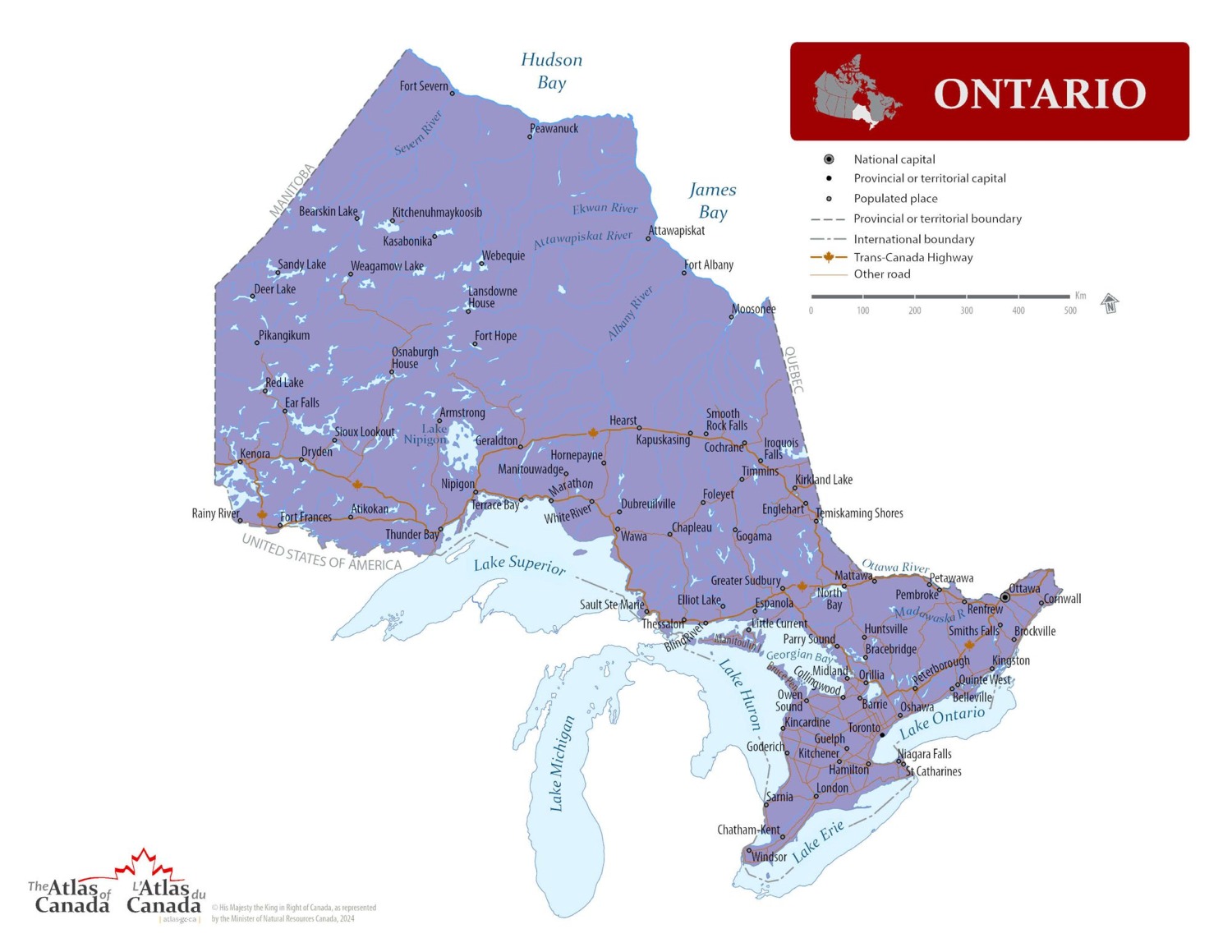
Map © Natural Resources Canada / Government of Canada
Ontario — Interactive Map
Explore Ontario with an interactive map featuring Street View, satellite and terrain views. Live weather, local news and location details for Ontario — built for travel planning and emergencies.
Map search is available for a limited number of queries per session to manage costs. Be specific — search precisely for best results.
| Province / Territory | Ontario (ON) |
| Capital | Toronto |
| Largest City | Toronto |
| Country | Canada |
| Nickname | Yours to Discover |
| Latitude | 51.2538 |
| Longitude | -85.3232 |
| Population | 14,223,942 |
| Cities & Towns | 5,716 |
| Area | 1,076,395 km² |
About Ontario
Ontario spans a vast northern reach where the rugged Canadian Shield meets the fertile plains of the south. Deep forests of spruce and pine dominate the central wilderness, stretching toward the cold, rocky shores of the great northern bays. Rivers carve through ancient rock, feeding into the immense freshwater basins that regulate the regional climate and provide life to the surrounding woods. To the south, the land softens into rolling farmland and the distinct limestone escarpment that defines the lower reaches of Ontario. Winters bring a profound stillness, locking the lakes in ice until the spring thaw awakens the landscape with a sudden, vibrant green. Travellers find that the quality of light changes as they move from the dense, dark timber of the north to the sun-drenched vineyards of the Niagara peninsula.
Indigenous peoples have served as the original stewards of these lands for thousands of years, navigating the complex waterways that connect the Great Lakes to the interior. European traders arrived later to establish outposts along the riverbanks, marking the beginning of a transformation that would reshape the entire region. The political boundaries of Ontario solidified through colonial treaties and the subsequent movement of settlers pushing westward from the eastern maritime borders. Industry and agriculture grew in tandem with the expansion of rail lines, turning remote settlements into booming hubs of commerce. Throughout these shifts, the people of Ontario have maintained a quiet endurance, building a modern society upon the foundational history of the fur trade and early agricultural development.
Manufacturing and resource extraction form the bedrock of the economy in Ontario, driving prosperity from the mines of the north to the assembly plants of the south. Gold and nickel are pulled from the earth in the rugged interior, while the southern corridor hums with the assembly of automobiles and advanced technology. Agriculture thrives in the temperate pockets of the province, where orchards and fields produce a bounty that sustains both local communities and international markets. Major urban centres act as financial engines, drawing talent and investment into a dense network of service-oriented businesses. Ontario remains a vital participant in global trade, leveraging its proximity to the American border to facilitate the constant flow of goods and services.
Sports and culture flourish in Ontario, where the passion for hockey remains a constant presence through the long, dark months of winter. Fans gather in grand arenas and local rinks alike, sharing in the collective tension of a close match on the ice. In the warmer months, the focus shifts to baseball, basketball, and soccer, with the streets of major cities filling with people celebrating their home teams. Festivals honouring music, film, and regional harvests fill the calendar, reflecting the diverse origins of those who call Ontario home. The culinary scene celebrates local flavours, from the crisp apples of the harvest season to the fresh catch pulled from the cold, deep waters of the inland seas. Daily life here is defined by a balance between the busy pace of urban life and a deep-seated appreciation for the natural world that lies just beyond the city limits.
Ontario Cities, Towns and Communities
A
B
C
D
E
F
G
H
I
J
K
L
M
N
O
P
Q
R
S
T
U
V
W
Y
Z
Ontario Maps — Interactive Map, Street View, Weather & News
This page provides an interactive Google map of Ontario (ON) with Street View, satellite and terrain views, alongside links to detailed street maps for 5,716 cities, towns and communities across the province. The provincial capital is Toronto.
Every location page includes live weather through Open-Meteo — with current conditions, hourly outlooks and 7-day forecasts — alongside real-time local and world news feeds. Wikipedia summaries and editorially written descriptions are included where available, and visitors can search Google directly from each page for additional context.
Location data is sourced from the Canadian Geographical Names Database (CGN), Natural Resources Canada, and verified by coordinates rather than name matching alone.