A large detailed map of Prince Edward Island
This is a large, detailed map of Prince Edward Island. There are links to many Prince Edward Island localities below. Our website format reduces the display size for uniformity. Here is a link to the full-size image that is more easily readable.
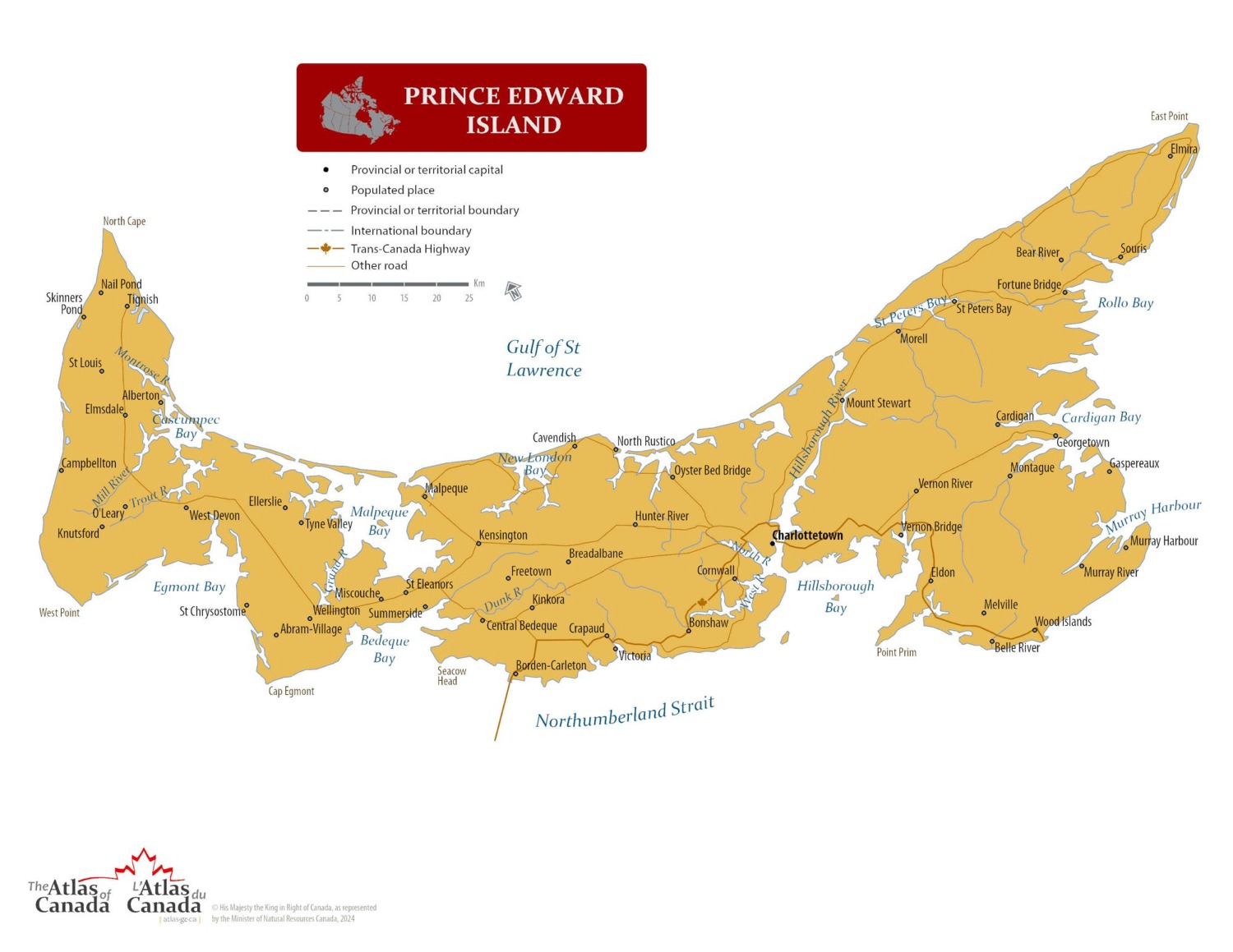
Map © Natural Resources Canada / Government of Canada
Prince Edward Island — Interactive Map
Explore Prince Edward Island with an interactive map featuring Street View, satellite and terrain views. Live weather, local news and location details for Prince Edward Island — built for travel planning and emergencies.
Map search is available for a limited number of queries per session to manage costs. Be specific — search precisely for best results.
| Province / Territory | Prince Edward Island (PE) |
| Capital | Charlottetown |
| Largest City | Charlottetown |
| Country | Canada |
| Nickname | Birthplace of Confederation |
| Latitude | 46.5107 |
| Longitude | -63.4168 |
| Population | 154,331 |
| Cities & Towns | 610 |
| Area | 5,660 km² |
About Prince Edward Island
Prince Edward Island emerges from the Gulf of Saint Lawrence as a crescent of iron-rich earth, defined by its signature red sandstone cliffs and expansive, salt-sprayed beaches. The interior landscape near the geographic centre reveals a quiet patchwork of rolling fields and woodlots, where the soil holds a vibrant, rusted hue that contrasts sharply against the emerald green of potato crops. Rivers carve slow, meandering paths toward the sea, creating sheltered estuaries that provide refuge for migratory birds and local fishing vessels alike. Provincial and national parks protect the fragile dunes and forest fringes, ensuring that the shoreline remains a wild boundary between the land and the cold, bracing Atlantic currents. Winter brings a heavy silence to the island as ice floes gather in the harbours, while the humid summers invite long evenings of soft, golden light that lingers over the meadows. Prince Edward Island maintains this distinct physical character through the interplay of wind, tide, and the enduring resilience of the red earth.
Indigenous peoples have held a profound connection to these shores for millennia, navigating the coastal waters and seasonal cycles long before the arrival of European explorers. The mid-eighteenth century brought a formal colonial presence, as settlers from France and later Britain established agrarian communities that gradually reshaped the island’s interior. Governance shifted through various imperial hands until the political developments of the nineteenth century solidified its position as a unique entity within the wider Canadian confederation. Prince Edward Island developed its administrative heart through a deliberate process of negotiation and maritime commerce, which remains central to its identity today. The architecture of the small villages and the layout of the rural roads echo the patterns established by those early pioneers who cleared the forests and surveyed the fertile plains. History on Prince Edward Island persists not as a relic, but as a living influence that informs the way the residents tend to their land and engage with the sea.
Agriculture serves as the primary engine of the local economy, with the island’s fame for its high-quality potatoes reaching markets across the globe. Beyond the fields, the commercial fishery dictates the pace of life in coastal communities, where the harvest of lobster and shellfish supports a network of processing plants and small-scale harbours. Tourism flourishes during the warmer months, drawing visitors to the quiet charm of the countryside and the historical appeal of the island’s heritage sites. Manufacturing and service industries have grown to support this primary production, creating a regional economy that balances modern innovation with traditional resource management. Charlottetown functions as the central hub for commerce and government, acting as the primary point of exchange for goods and ideas moving toward the mainland. Prince Edward Island manages its economic future by prioritizing sustainability, ensuring that the vitality of its resources continues to support the livelihoods of those who call the island home.
Cultural identity on Prince Edward Island is deeply rooted in the storytelling traditions of its diverse communities, where music and literature reflect the isolation and intimacy of island life. Festivals celebrating local food, traditional fiddle music, and the arts draw crowds throughout the year, reinforcing a sense of community that transcends the boundaries of the individual parishes. While the province does not host major professional sports franchises, the passion for local hockey and community-led athletics provides a strong social outlet for residents during the long winter nights. The culinary scene leans heavily on the harvest of the surrounding waters and the richness of the local soil, emphasizing a farm-to-table approach that is both practical and celebratory. Daily life on Prince Edward Island follows the rhythm of the seasons, marked by the arrival of the first spring thaw and the final gathering of the autumn harvest. Everything about the culture of Prince Edward Island suggests a people who are deeply attentive to the small, meaningful details of their environment.
Prince Edward Island Cities, Towns and Communities
#
A
B
C
D
E
F
G
H
K
L
M
N
O
P
R
S
T
U
V
W
Y
Prince Edward Island Maps — Interactive Map, Street View, Weather & News
This page provides an interactive Google map of Prince Edward Island (PE) with Street View, satellite and terrain views, alongside links to detailed street maps for 610 cities, towns and communities across the province. The provincial capital is Charlottetown.
Every location page includes live weather through Open-Meteo — with current conditions, hourly outlooks and 7-day forecasts — alongside real-time local and world news feeds. Editorial summaries and location descriptions are included where available, and visitors can search Google directly from each page for additional context.
The Search Maps button below the map opens the Canada Base Map with Toporama contours and shaded relief as base layers, with a labelled UTM grid overlay, a distance and bearing tool, and a single-fix GPS readout giving your UTM/MGRS grid reference and latitude and longitude.
Location data is sourced from the Canadian Geographical Names Database (CGN), Natural Resources Canada, and verified by coordinates rather than name matching alone.