A large detailed map of Yukon
This is a large, detailed map of Yukon. There are links to many Yukon localities below. Our website format reduces the display size for uniformity. Here is a link to the full-size image that is more easily readable.
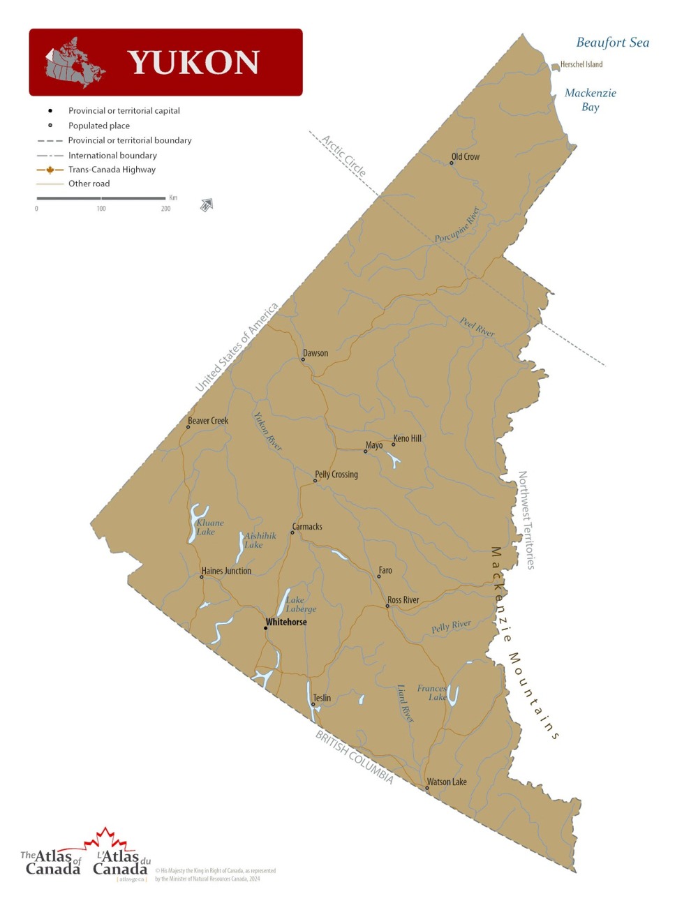
Map © Natural Resources Canada / Government of Canada
Yukon — Interactive Map
Explore Yukon with an interactive map featuring Street View, satellite and terrain views. Live weather, local news and location details for Yukon — built for travel planning and emergencies.
Map search is available for a limited number of queries per session to manage costs. Be specific — search precisely for best results.
| Province / Territory | Yukon (YT) |
| Capital | Whitehorse |
| Largest City | Whitehorse |
| Country | Canada |
| Nickname | The Yukon |
| Latitude | 64.2823 |
| Longitude | -135.0 |
| Population | 40,232 |
| Cities & Towns | 151 |
| Area | 482,443 km² |
About Yukon
Yukon's vastness unfolds under a sky that seems to stretch into eternity, a realm where mountains, ancient and stoic, pierce the clouds like slumbering giants. The land here is a grand tapestry woven from emerald forests, sapphire lakes reflecting the boundless heavens, and rivers that carve their serpentine paths through the wilderness, carrying whispers of the north. Here, the air itself feels pure, a crystalline draught that invigorates the soul, and the silence is a profound symphony punctuated by the cry of a distant hawk or the rustle of wind through spruce and pine. Venture into the heart of its protected spaces, and you'll discover landscapes sculpted by ice and time, where glaciers still hold dominion and the very earth breathes with untamed life. The climate zones shift dramatically across Yukon, from the boreal forests of the south to the stark, treeless tundra of the far north, each presenting its own unique, rugged beauty.
For millennia, the First Peoples of this land have been its stewards, their deep connection to the earth a testament to a profound understanding of its rhythms and resources. Their ancient traditions, passed down through generations, speak of a harmonious existence with the challenging yet generous environment of Yukon. European exploration and settlement, often driven by the lure of gold and the relentless spirit of the frontier, gradually shaped the modern character of Yukon. The echoes of the Klondike Gold Rush, a period of feverish activity and transformative change, still resonate in its historic towns and the enduring spirit of its people. This complex history, a blend of Indigenous heritage and colonial endeavour, has forged a unique identity for Yukon, a place where the past is never truly forgotten.
The economic engine of Yukon hums with a robust reliance on its rich natural resources, particularly the extraction of precious metals and minerals that lie beneath its rugged surface. This foundational industry, coupled with a growing tourism sector that draws travellers seeking adventure and untamed beauty, forms the backbone of its economy. Beyond these primary drivers, Yukon also supports a diverse range of service industries and emerging opportunities in areas like renewable energy and sustainable development, all contributing to the territory's economic vitality. While its population is spread across a wide expanse, key regional centres serve as vital hubs for commerce, community, and connection, fostering a sense of shared purpose throughout Yukon. The spirit of enterprise here is often intertwined with a deep respect for the land that provides its bounty.
Yukon's cultural landscape is as vibrant and varied as its physical terrain, a testament to the resilience and creativity of its inhabitants. While professional sports leagues may not have a direct presence, the spirit of competition and camaraderie thrives in local leagues and community-driven sporting events that celebrate the active lifestyle suited to this northern environment. The annual calendar is punctuated by a rich array of festivals and gatherings, each offering a unique window into the heart and soul of Yukon, from music and arts celebrations to events that honour its heritage. The cuisine reflects the bounty of the land, with an emphasis on local ingredients and traditional flavours, offering a taste of the north that is both comforting and unique. Daily life in Yukon is characterized by a strong sense of community, a deep appreciation for the outdoors, and a quiet pride in the extraordinary place they call home.
Yukon Cities, Towns and Communities
B
C
D
E
F
G
L
M
P
R
S
T
W
Ä
Ł
Yukon Maps — Interactive Map, Street View, Weather & News
This page provides an interactive Google map of Yukon (YT) with Street View, satellite and terrain views, alongside links to detailed street maps for 151 cities, towns and communities across the province. The provincial capital is Whitehorse.
Every location page includes live weather through Open-Meteo — with current conditions, hourly outlooks and 7-day forecasts — alongside real-time local and world news feeds. Wikipedia summaries and editorially written descriptions are included where available, and visitors can search Google directly from each page for additional context.
Location data is sourced from the Canadian Geographical Names Database (CGN), Natural Resources Canada, and verified by coordinates rather than name matching alone.