Humber Bay Arch Bridge
Home > Photos > Toronto Gallery - 1 > Humber Bay Arch Bridge
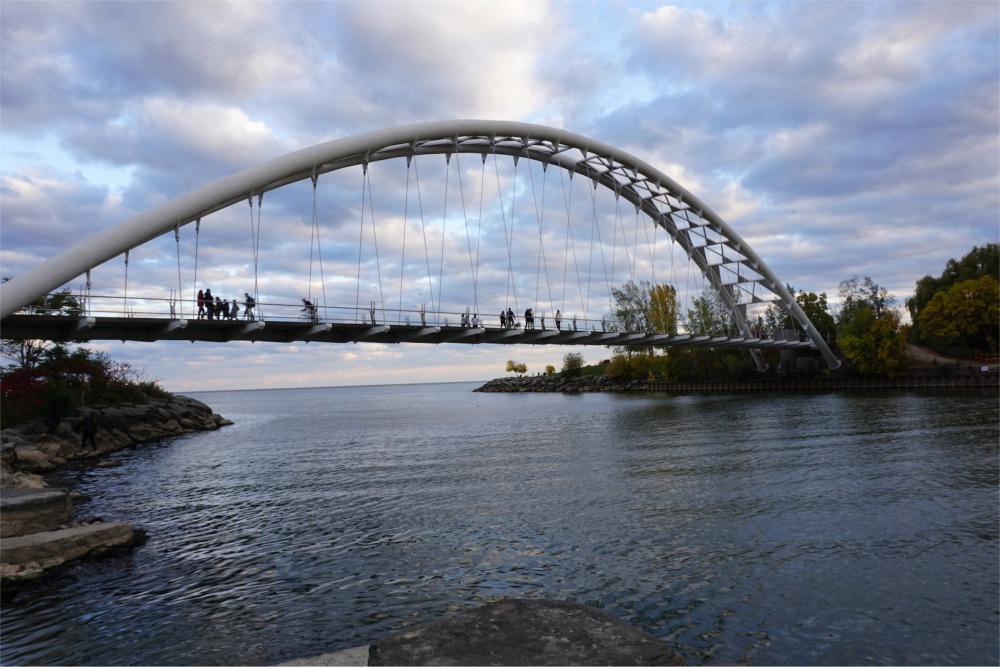
The Humber Bay Arch Bridge, also known as the Humber River Arch Bridge, is a notable pedestrian and cycling bridge located in Toronto, Canada. It spans across the Humber River, connecting the Humber Bay Shores Park in the west with the Toronto waterfront in the east. Here's some information about the Humber Bay Arch Bridge:
- Location and Design: The Humber Bay Arch Bridge is situated in the Humber Bay Shores Park area, just south of Lake Shore Boulevard West. The bridge is renowned for its distinctive design, featuring a graceful arch shape that spans approximately 139 meters (456 feet) across the Humber River. The arch rises to a height of around 21.3 metres (70 ft) above the deck.
- Architectural Significance: The bridge is considered an architectural landmark in Toronto and has won several awards for its innovative design. It was designed by Montgomery and Sisam Architects of Toronto and Delcan Corporation bridging engineers. The bridge's sleek and elegant appearance has made it a notable addition to the city's landscape.
- Pedestrian and Cycling Access: The Humber Bay Arch Bridge primarily serves as a pedestrian and cycling bridge, providing a safe and convenient connection between the Humber Bay Shores Park area and the Toronto waterfront. It offers a wide deck for pedestrians and cyclists, allowing them to cross the Humber River without interference from vehicular traffic.
- Scenic Views and Recreation: The bridge offers stunning views of the surrounding natural landscapes, including the Humber Bay Shores Park, the Humber River, and Lake Ontario. It provides an excellent vantage point for observing wildlife, such as birds and fish, as well as for enjoying the scenic beauty of the waterfront. The bridge is also a popular spot for recreational activities such as walking, jogging, cycling, and photography.
- Lighting and Nighttime Illumination: The Humber Bay Arch Bridge is illuminated at night, enhancing its visual appeal and ensuring safety for users during evening hours. The bridge's lighting design accentuates its architectural features and creates a striking visual presence along the waterfront.
- Connection to Trails and Parks: The Humber Bay Arch Bridge is part of a larger network of trails and parks in the area. It connects to the Martin Goodman Trail, which spans along the Toronto waterfront, offering pedestrians and cyclists access to a scenic and extensive pathway system. The bridge also provides easy access to Humber Bay Shores Park on both sides of the river, allowing visitors to explore and enjoy the natural surroundings.
The Humber Bay Arch Bridge serves as both a functional and aesthetically pleasing structure, providing an essential connection for pedestrians and cyclists while offering a captivating experience with its architectural design and scenic views.
Humber Bay Arch Bridge
The Humber Bay Arch Bridge (also known as the Humber River Arch Bridge, the Humber River Pedestrian Bridge, or the Gateway Bridge) is a pedestrian and bicycle through arch bridge south of Lake Shore Boulevard West in Toronto, Ontario, Canada. Completed in the mid-1990s, the bridge is part of the Martin Goodman Trail and is 139 metres (456 ft) in length, with a clear span of 100 metres (330 ft) over the mouth of the Humber River to protect the environmental integrity of the waterway.
Design
The bridge is constructed of two 1,200 millimetres (47 in) diameter high-strength steel pipes, bent into twin arches that rise 21.3 metres (70 ft) above grade, and suspend the deck by way of 44 stainless-steel hangers, each 50 millimetres (2.0 in) in diameter. The foundation consists of concrete-filled caissons which go down 30 metres (98 ft) below grade to the bedrock.
Designed in 1994 by Montgomery Sisam Architects of Toronto and Delcan Corporation (bridge engineers), it was constructed by Sonterlan Construction and is the recipient of numerous local architectural, design, and engineering awards. The bridge is situated at the mouth of the Humber River, the start of the "Toronto Carrying Place" trail, an ancient aboriginal trading route leading north, and thus features design elements and decorations such as carved turtles and canoes that evoke this native heritage.
The bridge forms an important pedestrian, recreational, and commuter cyclist link, and carries the Waterfront Trail, a multi-use pathway that will eventually parallel the entire north shore of Lake Ontario. The Toronto section is known as the Martin Goodman Trail and is one of the most popular pedestrian and cycling routes in the city.
Martin Goodman Trail
The Martin Goodman Trail is a 56-kilometre (35 mi) multi-use path along the waterfront in Toronto, Ontario, Canada. It traverses the entire lake shore from one end of the city to the other, from Humber Bay Arch Bridge in the west to the Rouge River in the east. The Martin Goodman Trail is part of the 730 km Waterfront Trail around Lake Ontario.
History
The trail opened in 1984.[5] It was named for the President and Editor-In-Chief of the Toronto Star who died three years previously. In March 1992, the Toronto Star reported that the then 18 km trail was in the need of repairs, having potholes and a lack of signage where the trail did not yet have dedicated lanes.[6] Repairs started in June 1992 with a $200,000 facelift.
Since 2005, Waterfront Toronto has been responsible for filling in gaps in the trail, particularly along the central waterfront, and maintenance. In 2006, they added an extension to connect to Tommy Thompson Park on the Leslie Street Spit, something first proposed in 1989. Starting in 2008 and finishing in 2009, a new 1.3 km section of the trail opened up along Lake Shore Boulevard at Ontario Place The new section of trail converted 8,000 square metres of Ontario Place parking lots into green space and trail.
Waterfront Trail
Stretching over 3600 km (2236 miles) from Prince Township, west of Sault Ste. Marie, to the Quebec border, the Great Lakes Waterfront Trail is a signed route of interconnecting roads and off-road trails joining over 150 communities and First Nations along the Canadian shores of the Great Lakes and St. Lawrence River. A celebration[peacock prose] of nature and culture, the Great Lakes Waterfront Trail is part of a strategy to protect and connect people to the largest group of freshwater lakes on earth. It is a legacy project of the Waterfront Regeneration Trust, a charity, and its community partners. Through Toronto, the trail is called the Martin Goodman Trail. The Waterfront Trail is also used by commuters in parts of Southern Ontario.
Expansion and future plans
In October 2013, Premier of Ontario Kathleen Wynne announced government support for the expansion of the trail system to better connect the 2015 Pan Am Games venues and community.
- I want to ensure that all of the people of this province benefit from our investments in the Pan Am and Parapan Am Games because that is how we can grow as One Ontario. Extending our trails system and connecting more communities is a great way for the excitement of the Games to live on well beyond 2015.
- — Kathleen Wynne, Premier of Ontario, October 3, 2013
The announcement ensures that "the province will work with First Nation and Métis communities and organizations to incorporate Aboriginal markers along the trails to honour the history and culture of Aboriginal communities in Ontario."
Trails will connect to four major Pan Am and Parapan Am Games venues — CIBC Pan Am/Parapan Am Athletes' Village, CIBC Pan Am Park, CIBC Hamilton Soccer Stadium, and Pan Am/Parapan Am Fields.
All consultations related to Pan Am/Parapan Am trails will address accessibility requirements under the Accessibility for Ontarians with Disabilities Act.
In November 2013, two waterfront-design firms were selected to reimagine the space at the former Ontario Place grounds in Toronto to incorporate a broader mandate for greenspace and parkland.
Since 2013, the Trail has been growing radically, with expansions along the shores of Lake Erie, Lake Huron, Georgian Bay and Lake Huron's north channel, adding over 2000 km to its length.
From Wikipedia, the free encyclopedia.